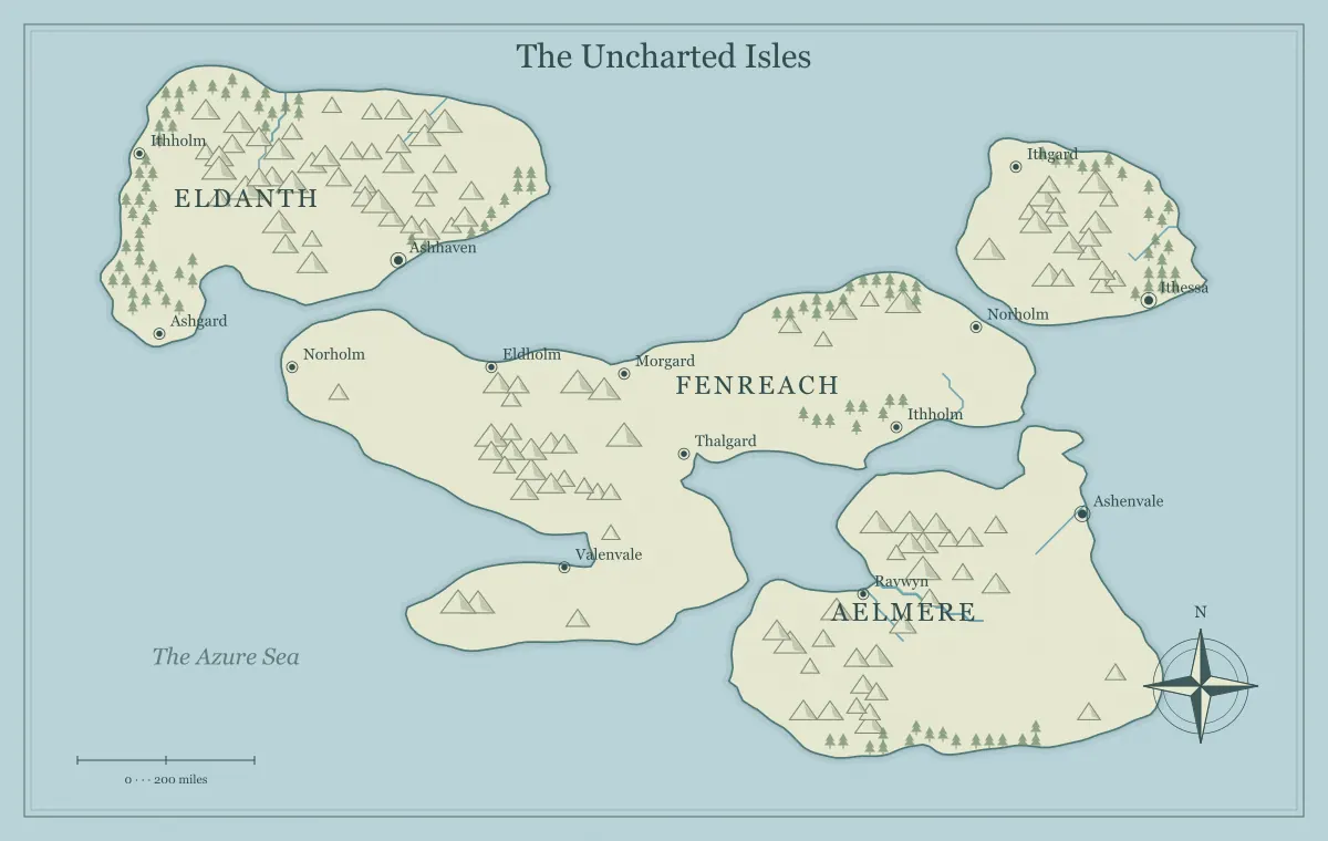
An archipelago feels like a connected world when its islands have relationships, not merely separate names. Some islands may provide food, others shelter, and another the main market where people exchange goods. The water between them can carry familiar routes, uncertain approaches, and distinctions between nearby communities. A useful map gives the audience a way to understand the group as a whole while preserving the identity of the places that matter individually.
This guide develops an original island region called the Pearlward Chain with the fantasy archipelago generator. The tool supplies fictional geographic illustration rather than a measured nautical chart or an ecological simulation. We will establish the island hierarchy, decide which relationships create a regional identity, and keep the overview readable. The approach suits a novel, a worldbuilding project, or a campaign without requiring every island to become a separate adventure.
Decide what makes this group an archipelago in your setting
Start with the region's identity. The Pearlward Chain may be recognized through shared travel routes, a common chart name, or a history of exchange. Its residents need not have identical culture or political affiliation. Decide who uses the group name and why. A merchant might describe the whole chain together while a local community identifies more strongly with one island.
Write the geographic extent of the group in your notes. The overview should show the islands whose relationships matter to the project, while distant neighbors can remain outside the frame. The map type guide helps distinguish an archipelago from a single-island setting, and the workflow guide connects the chosen extent to the audience's purpose.
Build an island hierarchy without making every island equal
Select the important islands first. Pearlward has a large market island, a food-producing neighbor, a repair and timber island, and several smaller landforms. Their significance comes from their function, not only their apparent size. A small island with a dependable landing can matter more to a particular journey than a large place far from the route.
Keep secondary islands available for later detail. You do not need an institution, capital, and complete history for every generated outline. The island shape guide connects broad frames to story uses. A hierarchy lets the map communicate a manageable regional structure while leaving room for a smaller island to become important when the project raises a specific question.
Interpret spacing through your chosen scale
The visual distance between islands does not establish a measured journey by itself. Decide the region's intended size, then apply consistent assumptions to movement and exchange. Two shapes that look close on a world overview may represent a substantial passage. A small local map may show a much shorter connection. Record the scope before attaching precise travel claims to the image.
The scale guide separates fictional distance, travel time, and image dimensions. In Pearlward, choose which connections are ordinary local travel and which require more preparation. That distinction can organize the setting without a complex numerical schedule. The important question is what the audience needs to compare, not how impressive a long list of exact distances looks in the notebook.
Use clusters and gaps to create regional structure
A cluster of nearby islands can support frequent exchange, while a more separated island can have a different relationship to the group. The outline does not dictate culture or authority, but it gives you a frame for deciding how regular contact works. Pearlward's market and food islands form the central cluster, while the repair island has a less direct connection and a distinct local identity.
Explain the contact through routes, transport, and institutions you establish. Isolation is relative: a place can be distant from the main market while connected strongly to another neighbor. Avoid treating every gap as empty space with no function. It may contain a passage, a meeting route, or simply a stretch that travelers plan differently. The trade guide develops these relationships through goods and practical needs.
Give useful landings a reason to matter
Decide where people commonly arrive and what they find there. A port with repair services differs from a small landing with no dependable supplies. The generated coastline does not measure depth, currents, or safety. Establish the fictional conditions relevant to the project and do not present the image as a real navigation aid. A useful landing has a practical role connected to people and routes.
Pearlward's market port handles public cargo, while a smaller island offers shelter and a local guide. Their different roles create a network. The coastline guide discusses bays, headlands, and river mouths, and city placement connects a port to inland resources. A settlement on the shore becomes more convincing when it has relationships beyond the edge of its own island.
Give islands complementary resources and limits
Choose what each important island can provide and what it needs elsewhere. The food island may supply the market, while the repair island provides materials and skilled work. The market can distribute tools and information. Keep the detail proportional to the setting. A few clear dependencies can explain regular exchange without requiring a complete economic model.
Avoid assigning one unique product to every island solely to make a tidy list. Several communities may produce similar goods while differing in access, quality, or relationships. The trade route guide connects production to movement, and climate planning helps keep broad environmental assumptions consistent. Research particular real resources when their properties are important to a precise claim.
Remember the interiors of larger islands
An archipelago overview can overemphasize ports and leave island interiors unexplained. Choose the inland relationships that matter. Pearlward's market island has a farming valley connected to the main port, while the repair island has a wooded upland and a supply route. Those features explain how the shore communities function and provide distinctions beyond the water passages.
Do not force a detailed local view into the regional chart. Keep broad terrain and important labels on the overview, then prepare closer notes or illustrations when needed. The river guide, mountain guide, and forest guide connect inland features to movement and settlement. The islands can feel inhabited without every minor valley appearing in the first handout.
Design routes as a network with alternatives
Identify the main passages and at least one useful alternative where the project needs choice. A direct route to the market may be familiar and serviced. An outer connection may avoid inspection but offer fewer stops. A local passage may require guidance. These differences should follow your fictional assumptions rather than appearing only as unexpected penalties after a traveler chooses.
Keep route knowledge obtainable. A chart, harbor conversation, or experienced traveler can explain the stable facts and identify uncertainty. The travel route guide develops those tradeoffs, while the pirate campaign guide applies them to ongoing play. For a novel, the same network can explain why a character's chosen route changes the people and information they encounter.
Separate regional patterns from current conditions
Decide what ordinary conditions make the network plausible, then distinguish the temporary event affecting a particular passage. A broadly reliable connection can be disrupted by a damaged landing or unusual weather. That event does not necessarily change the entire archipelago's identity. Record the specific constraint and its likely consequences so later scenes remain coherent.
For Pearlward, a damaged market pier can divert traffic to a smaller landing and increase demand for repairs. The alternatives become more important without requiring new island geometry. The climate guide separates long-term patterns from weather, and maintenance helps record changing route conditions. Keep physical changes and new knowledge distinct when updating the map.
Let political identity differ from geographic identity
The Pearlward Chain can have one group name while containing several administrations and independent communities. A shared market does not prove a shared government. A realm may claim the whole group while operating only a few ports reliably. Decide which political relationships matter and explain their meaning rather than assuming every island belongs to the same authority because they fit inside one chart frame.
Map the important public centers and keep detailed agreements in an index. The border guide distinguishes claims from practical control, while faction mapping connects influence to services and assets. A geography overview should remain readable even when political relationships become complicated.
Name the group, islands, and ports at different levels
The group name provides broad orientation. Individual island names identify landforms, and port names identify destinations. These levels should be distinguishable in the notebook and on the image. Pearlward Chain, Hearth Island, and Beaconport describe different scopes. Avoid using one name ambiguously for all three unless the setting explicitly does so and the audience can follow it.
Keep major spoken labels distinct and leave minor landforms unnamed until needed. The naming guide explains aliases and naming families, and label typography supports hierarchy. A broad water label should not compete with the port names the audience needs for a route decision.
Build the first Pearlward overview in three passes
In the first pass, identify the market island and two neighbors with different roles. Write one sentence explaining the connection between each neighbor and the market. The food island supports visiting crews and residents; the repair island supplies materials and work. This gives the chart a clear regional structure before you add every secondary name. Check whether someone unfamiliar with the setting can point to those three relationships in the image and nearby notes.
In the second pass, choose which minor landforms deserve a label now. A small shelter island on the ordinary passage can matter immediately, while a remote rock may remain unnamed. The decision follows use, not only size. Record provisional ideas for the other landforms outside the public chart so later development has room without making the first overview unnecessarily dense.
In the final pass, review the group name, island names, and port names together. Make sure each label has an obvious scope and that the important spoken forms are distinct. Save the working data and a reference picture before experimenting further. The result is a usable first regional view whose connections can support later scenes. You can expand Pearlward by answering a new question rather than rebuilding every island whenever the project grows.
Test Pearlward through one disrupted connection
Suppose the repair island's usual route to the market becomes temporarily unavailable. Identify who loses a service, which alternative becomes valuable, and what information travelers need. The market may delay repairs, the food island may offer a transfer landing, and local crews may negotiate access. Those consequences test whether the archipelago is a connected world rather than separate descriptions placed side by side.
Save the working file and inspect the actual export at the intended size using the export guide. A useful archipelago combines island hierarchy, route knowledge, complementary needs, and clear names. The generator offers a visual starting arrangement; your connected decisions give Pearlward a regional identity that can support stories and change while preserving the individuality of its islands.
Give the idea a world of its own.
Try the technique in the generator, then save an editable copy so you can return to your work.
Open the map maker ↗